Monday, September 5, 2011

Medina River Greenway, Upland Trailhead, East

Today's photos:


The Medina River Greenway trail from Applewhite Rd east to near Pleasanton Rd (jpg map link) reopened about a week ago after being closed for sometime for repairs. This section of the greenway trail is about three and a half miles long (one way). Most of the trail is on the upland cliff side of Medina River. I managed to walk about the first mile and a quarter today.

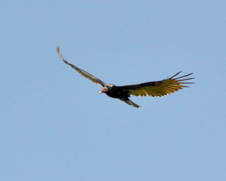
There were any number of intriguing encounters on the walk, such as the black-crested titmouse, the sparrow and the dragonfly. The turkey vulture gave me another demonstration of their aerial abilities. One thing I find interesting are the shapes that dead branches can have:


The weather was beautiful following the arrival of the first cool front of the season. There was a north wind blowing at 20 to 25 mph. It was refreshing just to hear the sound of the wind blowing through the trees. I began to wonder how the sound of the wind could be included photographically. Here is the best way I could think of doing that:


While the wind brought relief from the 100+ degree temperatures, combined with the exceptional drought conditions, it created an extreme danger of wildfires. The wildfire burning out of control in Bastrop County about a hundred miles or so to the northeast was very much on my mind on my walk today. Then when I was driving home and was just north of downtown on U. S. 281, I could see the plume of smoke from the Stone Oak Park fire in North Bexar County. There were at least two other wildfires in Bexar County today.

The danger of wildfires has been a major concern for me ever since my walk through Eisenhower Park on June 6th. The Stone Oak fire was started by a San Antonio Water System truck that parked in tall grass so a crew could access a manhole. Given the current conditions it takes so little to start a major wildfire.

When I left the Upland Trailhead following my walk on August 19, there was a grass fire burning just southwest of the Loop 1604, Highway 16 intersection. I even cropped one of the photos from that day's walk to eliminate the plume of smoke above the trees.

I have really been surprised there haven't been more wildfires. I took the following photos to show why there is such a danger of wildfire. An ember from a barbeque, a carelessly tossed lit cigarette butt, or anything similar would easily set this woodland ablaze:


Once again, there are a couple more sets of photos from my walk today that will be included in upcoming posts.

Saturday, September 3, 2011

Leon Creek Greenway, O. P. Schnabel Park Trailhead, North

Friday, September 2, 2011

Today's photos:


The O. P.Schnabel Park Trailhead is near the west boundary of the park, so to get to the Leon Creek Greenway (pdf map link) trail one must first walk east and south through the park. This is a good distance to walk in and of itself. Once I got to the greenway trail, I walked north on the paved trail to Prue Rd and returned on a dirt trail most of the distance back to the park trail. This section of the trail goes through riparian woodland that is very different from the trail north of Prue Rd.

It was another intense walk filled with any number of encounters that embody this blog's theme of inspiring wonder, awe and delight. Once again, I will let the photos speak for themselves. There were a couple more encounters I will present in upcoming Tuesday / Thursday posts. All the encounters: the dove walking across the trail, the flycatcher peeking out from the mesquite tree, the white-tailed deer and more, were literally unexpected, because I can never truly anticipate what will appear along a trail on any given day.

Thursday, September 1, 2011

The Crested Caracara

The Leon Creek Greenway (pdf map link) has a bridge that crosses high over the creek between the Bamberger Nature Park and the Fox Park trailheads. When I crossed the bridge walking north on Monday, Aug 22, there was one small pool of water remaining in the creek just south of the bridge. There were numerous small birds: cardinals, doves and mockingbirds, on the ground around the edge of the pool:


When I crossed the bridge again on my return walk south towards the trailhead, I was pleasantly surprised to find a Crested Caracara by the pool:


The Crested Caracara (a.k.a. Northern Caracara or Mexican Eagle) was the stuff of legend throughout pre-European contact in South and Central America. I haven't been able to find an authoritative website that discusses this, but there are numerous discussions on various websites. For example, the flags-flags-flags.org website has the following:
"According to Aztec legend the people were wandering in Mexico in search of a sign that their god, Huitzilopochtli, had given them. He commanded them to find a Crested Caracara perched on top of a cactus, devouring a snake. After two hundred years of wandering, they found the promised sign on a small island in the Lake Texcoco. Their search and wandering ended and they founded their new capital, Tenochtitl."
The Crested Caracara is actually in the falcon family, but unlike other falcons, spends most of its time on the ground. Its legs are very well adapted for walking and running.

Editorial comment:

In the interest of full disclosure, I will point out that I digitally removed a plastic cup that was among the debris in the creek bed from several of these photos. With the exception of the post on digital variations, this is the first time I have digitally altered any photos that have appeared in this blog. As a matter of editorial policy I will always indicate if a photo has been altered beyond correcting brightness levels and color correction.

The very prestigious National Geographic Magazine has been caught on several occasions publishing altered photographs that are supposedly straight documentary images without any indication to the audience of the alteration. Perhaps their most notorious example of this was the repositioning of the Great Pyramids of Egypt to make a horizontal photo fit the vertical format of the cover. Other major publications have also published significantly altered photos without indicating the alteration.

The Geographic's justification for the pyramid rearrangement was that they were "digitally repositioning the photographer." In other words, the rearranged photo is the way the pyramids would look if the photographer had taken the photo from a different angle.

Perhaps my justification for digitally removing trash is no better, but I'm digitally cleaning up the visually distracting and environmentally degrading trash that litters the trails and creeks. For the above series of photos, I want the emphasis to remain on the crested caracara, not the trash. In the photos, I can remove the visual distraction, but in reality, the environmental degradation remains.

In most cases, as I also mentioned in the post, "Nature and the Human Presence, A Few Reflections," I have been able to minimize distracting elements from photos either by selective framing or cropping. I will discuss creek bed debris and greenway trail trash in more detail in an upcoming editorial post.