Showing posts with label
San Antonio River Authority (SARA).
Show all posts
Showing posts with label
San Antonio River Authority (SARA).
Show all posts
Wednesday, July 9, 2014
Rivers flow not past, but through us; tingling, vibrating, exciting every cell and fiber in our bodies, making them sing and glide. – John Muir *
This set of photos was taken on my walk this past Wednesday along the Mission Reach of the San Antonio River from the VFW Blvd trailhead to the water edge landing downstream from the Mission County Park pavilion.
The Mission Reach ecological restoration project is a generational process that will take about 75 years to fully mature, so this is just the initial phase of the restoration. As the restoration matures the San Antonio River Authority (SARA) will allow the river channel to evolve within the limits of its primary function of flood control.
The section of the river pictured above is an excellent example of the natural evolution of the river channel. Through time, the channel will find its own natural course. Alterations naturally occur through the processes of erosion and deposition. This process is explained by Lane's Balance which deals with the relationship between the size and quantity of sediment carried by a stream versus the slope and flow rate of the stream.
The science aside, this is what the river is supposed to look like; the river healing itself.
* This quote from John Muir is from SARA's 75th Anniversary Documentary film: Sustaining and Enriching Life in South Texas; The Story of the San Antonio River.
The Grand Opening celebration of the final completion of the Mission Reach Ecosystem Restoration and Recreation Project will be held this Saturday, October 5th. This is the largest urban riparian ecosystem restoration to be completed anywhere in the United States. While this celebration marks the completion of the infrastructure construction, an ecosystem restoration of this magnitude is generational, requiring up to 75 years to fully mature.
The project is the result of extraordinary cooperation involving the U.S. Army Corps of Engineers, Bexar County, The City of San Antonio, the National Park Service, the San Antonio River Foundation and the San Antonio River Improvement Project with the San Antonio River Authority (SARA) serving as the managing partner. Kudos to all those at SARA who have worked so hard and continue to work to make this project a reality.
In celebration, all the posts here on While on a Walk this week and next will be of photographs taken along the Mission Reach.
The cormorants were very active along the river this past Monday. This is the time of year when the Double-crested Cormorants begin returning to spend the winter. Numerous flocks of nine to fifteen Double-crested Cormorants were flying upstream in the V-shaped formations most people associate with geese.
Meanwhile, a pair of Neotropic Cormorants were flying downstream:
This set of photographs was taken along the Mission Reach of the San Antonio River not far downstream from the Southcross Blvd bridge on Monday, September 30, 2013.
Monday, July 1, 2013
San Antonio River, Mission Reach, Mission Rd Trailhead downstream
Today's photos:
I really have been out taking a plethora of photos since April, even if there has only been one post since Earth Day. As the saying goes, there has been a lot of water under the bridge since then. Quite literally, there was a whole lot of water under the bridge during the major flood on May 25th with a record setting high crest on the San Antonio River under the Loop 410 South bridge.
The phrase "water under the bridge" typically refers to something in the past that is no longer important. All that has transpired since April 22nd is in the past, but still has significance both in the consequences of the events and in the lessons that must always be learned.
If all stays on course, I will discuss some of those events, their consequences and the lessons learned in an upcoming post. I have learned much in the past three months. For now, suffice it to say I did take a short walk along the River on Monday. I observed much, but took few photographs compared to my usual walks.
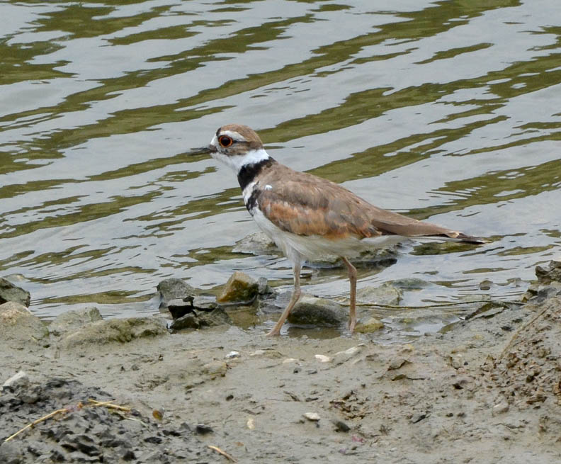
I'm not sure I can verbalize exactly why this Killdeer communicates my experience. I am probably projecting my own perceptions on it. Even after having had some time to study the photos, I still have a feeling this beautiful, wide-eyed bird was trying to re-orient itself to the changes in the post-flood river channel more than a month after the great flood of 2013.
Note: The San Antonio River Authority (SARA) has made considerable progress in reopening the Mission Reach trails damaged in the flood, however there is still much work to be done. If you are planning to visit the Mission Reach during the 4th of July holiday, please check SARA's website where there is an update with a link to a map showing current trail closures.
Tuesday, April 16, 2013
The San Antonio River Authority and City of San Antonio is presenting their second Elmendorf Lake Park Improvements Public Workshop this evening. This reminded me I have numerous photos of the wide range of birds I encountered on my walk at Elmendorf Lake Park on Friday, March 22, 2013 I have yet to post.
Most of the birds I photographed during this walk are common to the Lake. I will present those photos as a single set in Thursday's post. However, there was a small flock of Ruddy Ducks swimming on the Lake. This is a rather distinctive looking bird that I think deserves its own post:
Friday, March 22, 2013
Elmendorf Lake, On the large island
(with some photos from and back to the parking lot)
Today's photos:
This past Tuesday (March 19) I attended the Elmendorf Lake Park Conceptual Design Workshop cosponsored by the San Antonio River Authority and the City of San Antonio. At this meeting, the design team contracted to create a master plan for improvements to Elmendorf Lake Park (pdf link) presented initial design concepts and received community feedback for further consideration in the design process.
I am particularly interested in several items in the conceptual plan, such as a farmers' market and a community garden, but the one item that particularly caught my attention is the possibility of developing the "Island as Classroom." This part of the plan would improve the natural habitat on the island, incorporating specific teaching facilities for environmental and ecological studies and a dock for aquatic habitat studies. This concept for the island's improvement has tremendous potential.
So, for my walk today, I returned to Elmendorf Lake to take a closer look at the island.
- The first and second photos are views of the Our Lady of the Lake University Main Building and the Sacred Heart Conventual Chapel as seen looking across from the east side of the lake. One of the primary goals of the park improvement master plan is to preserve and enhance the historic connection between the University, Elmendorf Lake and the surrounding community. This goal will be accomplished in part, by preserving existing sight lines such as the one illustrated by these two photos and by creating new visual corridors.
- The third photo is a view from the east bank of the lake looking northwest at the southeast end of the large island. The trees on the island are primarily Huisache, which are currently in full bloom, Bald Cypress and Black Willow.
- The fourth and fifth photos were taken from the east bank of the lake looking south along the edge of the island. The fifth photo is a close up of the Huisache seen overhanging the lake on the left end of the fourth photo.
- The sixth photo is one of numerous Fox Squirrels that live in the park.
- The seventh photo is a view of the smaller "Bird Island" as seen looking west from the northwest end of the large island. As can be seen in this photo, "Bird Island" is a rookery for countless egrets and cormorants. All of the egrets I could clearly identify when I took this photo were Snowy Egrets, but there are also some Great Egrets nesting on this island. The cormorants include both Double-crested and Neotropic species. This island is a critical nesting site for these birds and I certainly hope its preservation as such is included in the master plan.
- The eighth photo is a Pipevine Swallowtail butterfly. This swallowtail was much more cooperative than the one I photographed Wednesday in Padre Park.
- The ninth photo is a young Bald Cypress setting new leaves. This tree is growing on the bank of the southeast end of the large island.
- The tenth photo is a view taken from the southwest bank of the large island looking north up the lake towards Commerce St. The vegetation growing along the banks of both the lake and the island are primarily Cattail and Elephant Ear. Both are very prolific and effectively stabilize the soil along the bank, but the native Cattail needs to be thinned out and the Elephant Ear, a non-native invasive plant, needs to be replaced with native plants such as Switchgrass or something similarly effective at bank stabilization.
- The eleventh photo is a large Mexican Honey Wasp nest high up in a Bald Cypress on the bank of the lake. Mexican Honey Wasps are fairly common in Bexar County and are one of the most important native pollinating insects. They are one of very few species of insects other than bees capable of producing honey.
- The twelfth photo is a close up of a Bald Cypress branch with freshly set new leaves.
- The thirteenth through fifteenth photos are close ups of Black Willow flowers. The Honey Bees were taking full advantage of this ample supply of nectar.
- The sixteenth photo is a Great Blue Heron on the large island as seen looking across the lake from the east bank. While the heron provides a visual point of interest in the photo, my primary reason for including the photo in this series is because it effectively shows how the landscape on the island is currently highly manicured in traditional park-like fashion. If the island is eventually developed as a classroom for environmental studies, the landscape should be wildscaped instead of manicured.
As with my walk at Elmendorf Lake on January 7, I was again impressed by the number and diversity of species of birds around the lake. I took numerous photos of the birds and will publish them in two or three more posts in the near future.