Wednesday, February 6, 2013
Eisenhower Park, Cedar Flats > Yucca Trails
Today's photos:
Today's walk was through the southern, lower elevation half of Eisenhower Park. This park was the second in the San Antonio Parks and Recreation Department system to be designated as a Natural Area. Friedrich Wilderness Park was the first with that designation.
Eisenhower Park is located in north central Bexar County within the Edwards Aquifer Recharge Zone. The park also occupies a unique and critical topographic location in that its rain runoff drains into three of Bexar County's five major watersheds. Rain water runoff that drains from the southeastern and southern boundary of the park, which is the major amount of runoff from the park, enters the Olmos Creek / San Antonio River watershed. This is the northern most direct source of that watershed.
Runoff that drains to the east from the northeast corner of the park enters the Salado Creek watershed. Runoff draining to the west from the northwest corner and western boundary enters the Leon Creek watershed. Of course, both the Salado Creek and Leon Creek are tributaries of the San Antonio River with confluences in south Bexar County, so all of the runoff eventually ends up in the San Antonio River.
The long range development plan of the Parks and Recreation Department includes the extension northward of the current Salado Creek and Leon Creek Greenway trails to have them converge at a common location in Eisenhower Park. The completion of that plan is a long way off in the future, but is something to look forward to having in place.
Today's photos are a brief glimpse of all the images that I have from this walk. There will be two more upcoming posts with more specific topics.
- If I had to select one photo that illustrates the vegetation of the Edwards Plateau ecoregion, it would probably be the first one in this series. Growing low to the ground in the foreground are several Twisted-leaf Yucca plants. This species of yucca is only found as a native plant on the Edwards Plateau. Behind the twisted-leaf yucca are several Sotol, another plant characteristic of the region. And behind the sotol is an Ashe Juniper sapling. To the right of the ashe juniper is the sapling of a deciduous hardwood, but I'm not certain which species it is.
- The second, third and fourth photos are a Shiny Flea Beetle (Asphaera lustrans). This is another creature where I wonder how it got its common name. It is obviously a shiny beetle, but it has nothing at all to do with fleas.
- The fifth photo is a snail shell. Based on personal observation, I know this is one of the very common snails in Bexar County and it has a beautiful shell, but that is about the limit on my knowledge of snails. It looks like a Striped Rabdotus (Rabdotus alternatus), but don't quote me on that.
- The sixth, seventh and eighth photos are of an Eastern Cottontail Rabbit (Sylvilagus floridanus). I have seen cottontails in Eisenhower Park before, but they have all been back in the brush. This one sprang across the trail right in front of me, stopped right as it entered the undergrowth and looked back at me for a minute or two before hopping off down the hill as if it had somewhere it needed to be.
- The ninth and tenth photos are of the ubiquitous Northern Mockingbird (Mimus polyglottos). I was thinking this was going to end up being a walk without a bird sighting, but this mockingbird was apparently waiting for me next to the parking lot wen I returned to my car. When a creature poses for a photo, I can't easily pass up the opportunity.
If all goes according to plan, tomorrow's post will be "A Bloomin' South Texas Winter."
Monday, February 4, 2013
Crownridge Canyon Natural Area, Red Oak Loop Trail, once around the loop
Today's photos:
Following a very intense week along the San Antonio River, it was time for a bit of a change of pace. Crownridge Canyon Natural Area is located in the upper Leon Creek watershed in northwest San Antonio. It was the first natural area developed by the San Antonio Parks and Recreation Department as part of the Edwards Aquifer Protection Initiative.
This Natural Area is a box canyon on the periphery of the Edwards Escarpment. It has a very different ecosystem from the riparian ecosystem which is being restored along the San Antonio River. This post focuses on the lay of the land and some of the vegetation found in the canyon. The next post will feature "A Few Critters in Crownridge Canyon."
- The first photo is an oak motte in a savannah restoration area in the Natural Area. The trees in the background are growing on the wall along the west side of the canyon.
- The second photo is a Sotol with Ashe Juniper (Mountain Cedar) in the background.
- The third photo is the view looking upstream from the Red Oak Trail Overlook bridge.
- The fourth photo is a close up of the young bark that is characteristic of the Escarpment Black Cherry. The bark loses the silver stripes and changes texture as the tree matures.
- The fifth photo is the top of an Ashe Juniper.
- The sixth photo is Wafer Ash seeds. Like the mountain cedar, the wafer ash is another example of how common names, versus scientific names, can be misleading. The mountain cedar isn't a cedar and the wafer ash isn't an ash. The wafer ash is actually in the citrus family. It is also known as a hoptree.
- The seventh through tenth photos are Evergreen Sumac. I was impressed by the abundance of evergreen sumac still with their red berries as I walked the trail. The evergreen sumac is an excellent shrub for native landscaping. The flowers attract butterflies and the berries are food for a wide range of wildlife.
Sunday, February 3, 2013
The Measure of Success
"That land is a community is the basic concept of ecology, but that land is to be loved and respected is an extension of ethics. … We abuse land because we see it as a commodity belonging to us. When we see land as a community to which we belong, we may begin to use it with love and respect. … Examine each question in terms of what is ethically and aesthetically right, as well as what is economically expedient. A thing is right when it tends to preserve the integrity, stability, and beauty of the biotic community. It is wrong when it tends otherwise." - Aldo Leopold
 |
| 1 |
 |
| 2 |
 |
| 3 |
 |
| 4 |
 |
| 5 |
 |
| 6 |
 |
| 7 |
 |
| 8 |
 |
| 9 |
 |
| 10 |
 |
| 11 |
 |
| 12 |
 |
| 13 |
 |
| 14 |
 |
| 15 |
 |
| 16 |
 |
| 17 |
This past week I have had the pleasure of being involved in several programs dealing with various aspects of the San Antonio River Mission Reach and the River Restoration Project. To end the week, yesterday morning (Saturday, February 2, 2013) I participated in a birding hike sponsored by the San Antonio River Authority.
The photos in this series are from that hike. During the morning, we covered the area roughly bounded by Lone Star Blvd to the north, the western half of Roosevelt Park then south along Mission Rd to the railroad tracks just north of U.S. 90 and the San Antonio River Greenway to the west.
The goals of the San Antonio River Restoration Project are philosophically and ethically consistent with the Aldo Leopold quote with which I opened this post. One of the primary goals of the project is to provide habitat for birds that migrate along the Central North American flyway.
One measure of the success of the project is the number of birds that can already be found along the Mission Reach, even though the project is far from completion. In a sense, these birds are the "canaries in the coal mine" that indicate the habitat improvement is working.
Yesterday a total of twenty seven species of birds plus one sparrow of unidentified species (not a house sparrow were sighted. The photos presented here include thirteen of those twenty seven species:
- The first photo is a spotted sandpiper. This particular sandpiper has its spotless winter plumage.
- Photos two and three are a 'Myrtle' yellow-rumped warbler.
- Photo four is an European starling. These birds were first introduced to New York City in 1890 and have since spread throughout the entire continental United States.
- Photo five is a house finch.
- Photo six is a house sparrow landing at the top of a twig. Growing up in St. Louis, we referred to these as English sparrows which indicates their Eurasian origin. Like the starling, they were introduced from Europe. They have spread worldwide.
- Photo seven is a red-tailed hawk. This hawk was in the process of building its nest and can be seen carrying a twig in its beak in this photo.
- Photo eight and nine are a little blue heron. There were a pair of them on the river yesterday. This pair has returned to Bexar County a little early this year. They usually don't return until mid-March.
- Photo ten is a great egret. They are year around residents. The river wouldn't be the same without them.
- Photo eleven is a loggerhead shrike perched at the top of a tree seventy to seventy five yards away from the camera. I wouldn't have been able to identify this shrike based solely on this photo, but fortunately, we did get a better look at it while we were there.
- Photo twelve is a pair of gadwalls. There were at least five or six pair on this section of the river yesterday.
- Photo thirteen is a great blue heron. Great blue herons are close cousins of great egrets. Both are in the Genus Ardea.
- Photo fourteen is a neotropic cormorant.
- Photo fifteen is another red-tailed hawk. There was a pair of these hawks nesting on top of a cell phone tower.
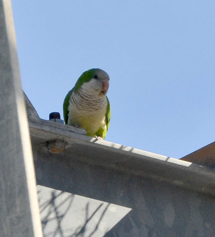
- Photos sixteen and seventeen are feral monk parakeets. These parakeets are native to central South America. They were first introduced to the United States in 1967. Feral colonies are becoming increasingly common throughout the East Coast and Gulf Coast states. There is a flock of them nesting in an electric transmission station on Mission Rd.
Note: This post has been updated, 5 February 2013 at 3:15 PM, from the original to correct the number of species sighted on this bird hike.