Friday, August 12, 2011

Medina River Natural Area; Rio Medina > Nogales > El Chaparral Trails

Today's photos:


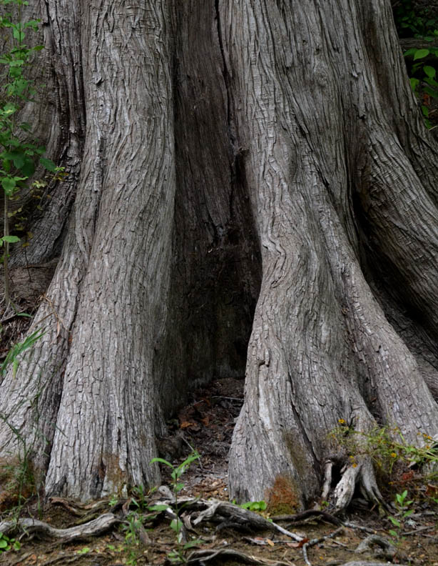
The Medina River Natural Area includes very diverse ecosystems. Walking the trails in the order I did today took me from the river bank through the riparian woodland to the chaparral of the upland area. This was another three hour walk. I could easily have stayed all day if there hadn't been other things I needed to do today.

The Nogales Trail (nogales is Spanish for walnuts) connects the river bank area to the chaparral with most of its length along a high tension electrical easement. The easement has been cleared of trees, but turks cap and Texas bindweed abound attracting numerous butterflies. I will post the butterfly photos in a future Tuesday or Thursday post.

Thursday, August 11, 2011

Crescent Bend Nature Park; Along the Water's Edge Edition

This past Friday, August 5, I went to Crescent Bend Nature Park with the primary intention of walking the upland trail. But it's a fairly safe bet that if I'm that close to a body of water, I'll end up spending some time at the water's edge (or the edge of where water has been as is frequently the case in South Texas). So, Friday before leaving the park, I did wander down to Cibolo Creek and took numerous photos along the water's edge.

The low water crossing at Schaefer Road just east of the park entrance also serves as a weir dam creating a large pool of water above the crossing. It is this pool of water, a small "lake" by Texas standards, that was the source of the name for the Lakeview Subdivision.


As I mentioned in an earlier post, this was a very prolific walk photographically. There are three more series of photos I will be posting on the upcoming Tuesdays and Thursday.

Wednesday, August 10, 2011

Medina River Natural Area, An Introductory Walk

Today's photos:


The Medina River Natural Area is on the far southwest side of San Antonio off of Hwy 16 south of Loop 410. My walk was fairly short in terms of distance this morning, maybe three-quarters of a mile tops, but as anyone who has been following this blog may suspect by now, I spent a lot of time along the bank of the Medina River taking photos. I walked along the Rio Medina Trail where it begins just below the pavilion to the first unnamed short path up to the El Chaparral Trail and walked back to the park entrance.

As can be seen in the photos, there is water in abundance flowing in the Medina River. Unlike the San Antonio River, the Medina has not been channelized, so the runs, pools and riffles are in there natural state. Prior to channelization the San Antonio River had a similar appearance to the Medina.

When I returned to the park entrance, I turned the camera off before going in the park office to get some additional information about the trails. As I approached the porch in front of the office, I noticed this "guard" on a rock off to the side at the bottom of the steps and had to turn the camera back on to get a couple more photos:


Once again, I took more photos than I have posted today and will include the additional images in a future post.

There are 5.74 miles of trails in the Natural Area. El Chaparral Trail is the Medina River Greenway Trail with a total length of 6.64 mile (one way as at it is frequently pointed out) extending from the Natural Area entrance to almost 4 miles east of Applewhite Rd. There's no doubt I will be returning for many more walks.